November, 2000
 Previously I reported here that on my first outing with the new kayak, I had gone into Cold Creek Lake and on to the brink of the Mississippi River. After studying my maps and making a return trip the next week, I realized I had made a mistake in my description of what I had seen due to a last minute change in the location of the launch. I had originally intended to put in at the ramp inside Fort Pillow State Park, but when I arrived there, I found the road to that ramp washed out and unusable, therefore I went outside the park to the public ramp. That ramp put me into Cold Creek, and the large body of water I had paddled to was not the Mississippi, but rather Cold Creek Lake itself. On most maps, the lake is shown connecting to the Mississippi River, but I subsequently learned from a fisherman that the river has to reach 17 feet on the Memphis gauge before the river comes into the lake. I contented myself over the month of September with exploring Cold Creek Lake and decided not to correct the information in the previous report, because it was an honest mistake and my friends told me it was a good story as it was.
Whenever I would tell people I wanted to get out into the Mississippi River in my kayak, the reaction was always the same: “Are you crazy? That’s dangerous... isn’t it?” Well I used to think so, but after driving over it several times a day for the past ten months I came to see the river in many different moods, and most of the time it was a calm, non-threatening mood, mainly because of the low water level after a summer and fall of drought. Most days when I cross it, the river looks as calm as a swimming pool. Early mornings especially seem to find it glassy, almost as if frozen. Having spent a month on the lake getting used to my boat and building my stamina, I felt ready to meet the Mississippi, but there was still some planning needed.
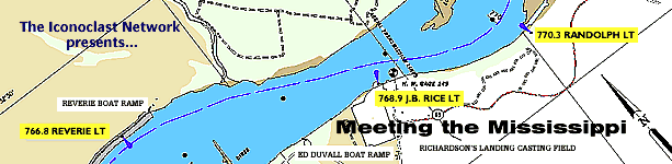
The local outfitter has a pamphlet which describes an 18 mile trip from Shelby Forest to the Memphis riverfront as being “for experienced paddlers with knowledge of the Mississippi River and the rules of navigation.” My experience level was debatable, but I definitely lacked the last two items. Not to be deterred, a web search turned up quite a bit of useful information in the form of complete river charts compiled by the U.S. Corps of Engineers from 1998 data, the most recent available. These maps are indexed and printable PDF files available here. These charts show the locations of all navigational lights and buoys, as well as the shipping channel and prominent sandbars, levees and place names. From studying these maps, I knew I would be finishing my trips at Duvall Landing near Randolph, TN, and I could begin my trips from several different points upriver. On a scouting trip to Duvall Landing, I met a fisherman who pointed out a sharp bend in the river just upstream from the landing, and admonished me to “keep to the sandy side there,” as barges going upstream had to use all their power to make that turn and in doing so they kick up tremendous turbulence, including standing waves which he described as being “six to eight feet tall.” The navigation rules are easy enough... the channel is marked with red and green buoys. Vessels going up stream keep the red buoys on their right and the green ones on their left, and obviously this is reversed going downstream. Motorized vehicles in the channel must adhere to this as well, and non-motorized such as myself must keep out of the way! To put it more formally, the more maneuverable boat must keep out of the way of the less maneuverable ones, such as barges.
For my first river adventure I chose to put in on the Hatchie River at an old ramp known to me as Burlison Landing (also known as Club Road landing). There is an abandoned ranger station there for the Lower Hatchie Wildlife Refuge. It is about five miles from there to the Mississippi River and then five more miles to Duvall Landing.

This page is about Mississippi River kayaking, or kayaking on the Mississippi River.